
Key Findings
-
Unmanned aircraft systems (UAS) enable new methods of data collection, which are relevant to surveys.
-
UAS show promise in creating frames of dwellings for household sampling.
-
UAS may also facilitate remote video interviewing.
-
UAS equipped with sensors can supplement survey data with characteristics previously unmeasurable in surveys.
Unmanned aircraft systems (UAS) are valuable data collection tools: they can carry a payload of sensors such as high-resolution cameras, infrared sensors, and air-quality monitors, and they are inexpensive and easy to operate. UAS are already used to collect data on plants and animals (Cell Press, 2016; Chuchra, 2016; Hodgson et al., 2016). They may soon deliver packages to our homes (Wingfield & Scott, 2016). As they become more common, UAS will observe many things about our lives, such as traffic patterns and uses of green space.
We believe that the extension of UAS into survey data collection is only a matter of time. Researchers should think carefully about the role that UAS might play in survey data collection and conduct tests of some of these approaches where and when possible. We can then be prepared to deploy UAS-based solutions in survey research as the legal and cultural climate permits. In this brief, we discuss three potential applications of UAS technology in survey data collection: (1) supplementing survey data with photo and sensor data; (2) bringing survey-capable devices to respondents; and (3) detecting and enumerating housing units for sample selection. We have previously presented some of these ideas at conferences and gather them in this brief to spark wider discussions.
Idea 1. Supplementing Survey Data with UAS Photo and Sensor Data
Respondents do not always give accurate responses to survey questions. They may overreport socially desirable behavior, like voting or exercise, and underreport undesirable behavior, like drug use (Tourangeau & Yan, 2007). Other items of interest they may simply not know about or may not be interested in investigating, such as the year their house was built or the gas mileage their car gets. Collecting more data passively, without asking questions, can help make surveys shorter and more accurate. UAS-based cameras and sensors are one way of collecting passive data.
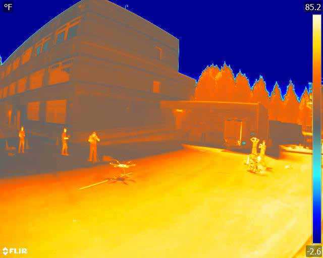
For example, energy surveys such as those conducted by the Energy Information Administration track the energy consumption of residential and commercial buildings in the United States. The surveys collect measures of the square footage of selected buildings, but these measures can be hard for respondents to report correctly (US Energy Information Administration, 2017). UAS equipped with cameras could fly around and over the sampled buildings, taking pictures from which estimates of square footage can be made. The energy efficiency of the selected buildings might also be of interest, but respondents are unlikely to be able to provide this information. However, UAS equipped with long-wave infrared cameras can detect energy loss. The market leader for these cameras, from FLIR, costs about $3,000 (https://www.flir.com/products/vue-pro-r/). Figure 1 shows an image taken by such a camera; from this image, energy loss can be calculated (Ariwoola, 2016). The low cost of this technology could enable data collection at different times of the day and week and in different seasons, allowing for comparisons of functions of time and occupancy levels (Mauriello & Froehlich, 2014). Improved data on energy loss would increase the accuracy and value of the data collected in energy-consumption surveys.
In addition to long-wave infrared cameras, UAS can carry other sensors, such as high-definition visible or ultraviolet cameras, which can provide data on pollution and air quality. We believe that the combination of UAS and various sensors will be an area of significant growth in the coming years. Such sensor data can add value to survey data.
Idea 2. Bringing Survey-Capable Devices to Respondents
Many people are familiar with the survey kiosks in public areas that ask how the airline check-in process went, or how we found the customer service experience at a store. The kiosks often have four buttons with varying colors and faces to indicate levels of satisfaction or dissatisfaction. Such kiosks are easy for nearly everyone to use, but they can ask only one question, are in a fixed location, and are easily overlooked.
UAS, carrying tablet computers, could similarly deliver short interviews to respondents and would not be fixed in one location: Google already has a patent on a tablet-carrying UAS for video teleconferencing (Lutero, 2017). A survey UAS could replace the survey kiosks and other intercept interviews at popular gathering places. The tablet could deliver written questions, which respondents could answer by speaking, touching a response option, or even gesturing (thumbs up, thumbs down). Alternatively, the tablet could deliver spoken questions via a video interview with a live, recorded, or animated interviewer. A SIM card would provide a fast internet connection and allow the UAS to capture and transmit data almost anywhere.
Mobile web and SMS surveys can also engage with people while they are out and about, but they are not standardized across devices—the appearance and functionality of a given questionnaire vary with phones’ operating systems, screen sizes, and orientations (Callegaro et al., 2015). In contrast, a survey UAS could deliver a questionnaire or interview with a standardized look and feel, because the survey provider would control the hardware and software.
Many challenges must be addressed before this approach is adopted. Some respondents will find a survey UAS so intrusive that they refuse to take part. Others may find it novel and interesting. Eyerman and colleagues (Eyerman et al., 2013) recently published research into public acceptance of UAS. Clear ethical guidelines should also be in place before UAS begin flying around asking questions. We return to this point in the last section.
Idea 3. Detecting and Enumerating Housing Units for Sample Selection
When no list of all people or households in a study area is available, many surveys use housing unit listing to create a frame of households inside selected clusters (Grosh & Munoz, 1996; Harter et al., 2010; Heeringa & O’Muircheartaigh, 2010). Listing involves sending field staff to the clusters to create a list of all housing units in the area: staff write down the address or description of each dwelling. The list is then returned to the central office where it is reviewed for quality, and a sample is selected. Interviewers return to the area and carry out the survey. The method is not without problems, but coverage is generally high (Eckman, 2013; Eckman & Kreuter, 2011, 2013). However, listing can put field staff at risk for robbery or kidnapping, because it involves walking systematically down all streets, as opposed to interviewing, which often takes place inside respondents’ homes (Shannon et al., 2012). Listing also adds to data collection costs because it requires two trips to the area—one for listing and another for interviewing.
UAS could do many of the listing tasks. An interviewer could launch a UAS from somewhere near the selected cluster. It would fly around the selected area, using its GPS device and preloaded cluster boundaries to ensure that it stays inside the cluster. It could take pictures of all structures in the cluster and use a machine-learning algorithm to detect which structures contain residential units and how many. Software would then select a sample of residential units and transfer the pictures and coordinates of the selected units to the interviewer’s tablet. Interviewers would then visit only the selected units. This approach eliminates the need for two trips to the cluster and would be particularly useful in remote areas that are difficult to reach. Using UAS for housing unit listing could make listing faster and less expensive and thus improve survey coverage, especially in quickly evolving areas such as refugee settlements or internally displaced persons camps. Given the record number of displaced people in the world and the growing interest in understanding the challenges they face, UAS listing could make an important contribution to research.
The pictures taken by the UAS during listing could have other uses as well. Housing unit characteristics, such as socioeconomic status, could be coded from the images manually or via machine learning. As an example, Kirkpatrick (Kirkpatrick, 2017) used machine learning to code roof types (thatch or metal) as a proxy for household income. Housing unit characteristics captured in the UAS photos could be useful for sample stratification or nonresponse adjustment. In addition, the location information embedded in the photos could support a real-time verification system to identify interviews done at an incorrect location.
Portions of this process are already feasible. RTI researchers have tested the use of UAS to take georeferenced photos of buildings for manual coding of residential units by office staff in the Galapagos (Amer et al., 2016). Machine learning algorithms to detect residential buildings are increasing in accuracy (Hecht et al., 2013; Hermosilla et al., 2011; Herold et al., 2002; Jensen & Cowen, 1999; Meng et al., 2012; Rottensteiner et al., 2014; Salehi et al., 2012; Thompson, 2003; Ural et al., 2011; Vanderhaegen & Canters, 2010; Yan et al., 2015; Yu et al., 2011). Thus, listing and sampling via UAS should soon be technically possible. Legal and cultural acceptance will likely take a bit longer in some countries.
Future Work
We present these ideas with the knowledge that there are currently legal obstacles to the widespread use of UAS in many countries, including the United States. Currently, US drone pilots cannot fly UAS for commercial purposes (which includes research) beyond the line of sight, above 400 feet, in restricted airspace, and over people who have not given prior permission. However, operators can obtain waivers for these requirements if they can prove that their planned operations are safe. The Federal Aviation Administration is actively adjusting the regulations to permit a wider range of safe operations in the United States (Federal Aviation Administration (FAA), 2018). Regulations are different, and sometimes less restrictive, in other countries. A database of drone regulations in all countries is available at https://www.droneregulations.info/.
There are nonlegal obstacles as well. Even after the laws change, it may take time for many people to accept the fact that UAS are in the sky collecting data and images. A public opinion survey conducted in 2015 indicated that 75% of respondents were very concerned or somewhat concerned about “drones being used to monitor the actions of people outside their homes.” However, younger people were more accepting, suggesting that public opinion on UAS may change in the future (reanalysis of data in Evans et al.) (Evans et al., 2016).
There are also technical barriers. Even if all the legal and cultural barriers disappeared tomorrow, we are not ready to implement any of the ideas outlined previously; additional research and development are necessary. Ideas 1 and 3 (Supplementing Survey Data with UAS Photo and Sensor Data and Detecting and Enumerating Housing Units for Sample Selection), for example, depend on “smart-drone” technology—UAS that can process data while flying and collecting data. Current low-cost UAS must return to the ground and transmit data to another computer for processing, but we are confident that manufacturers will continue to advance the capabilities of UAS.
Although technological barriers will likely be overcome by the market, ethical guidelines and best practices for data collection via UAS will not be. For that reason, researchers should help establish human subjects protection guidelines relating to using UAS for surveys and data collection more broadly. Unfortunately, we are not aware of any researchers or professional groups currently working on ethical guidelines for human subjects research with UAS.
We should not wait until US regulations change to begin testing the use of UAS in survey data collection. If we wait, survey researchers will miss the opportunity to guide the UAS industry, which is growing quickly. We should contribute to the development of standards, best practices, and methodological guidelines for the use of UAS for applied research and technical assistance. We can also think about the types of sensors that would be most useful to our clients and guide the industry in that way. Just as survey researchers were quick to see the potential of telephones for survey administration and the use of computers for computer-assisted interviewing, we should now begin thinking about and testing how we will use UAS to collect information that can supplement and improve survey data.